


JEFFERSON, Washington County, Indiana
About
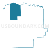
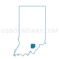
Outline

Summary
| Unique Area Identifier | 581180 |
| Name | JEFFERSON |
| County | Washington County |
| State | Indiana |
| Area (square miles) | 48.74 |
| Land Area (square miles) | 48.10 |
| Water Area (square miles) | 0.64 |
| % of Land Area | 98.70 |
| % of Water Area | 1.30 |
| Latitude of the Internal Point | 38.70925720 |
| Longtitude of the Internal Point | -86.16383610 |
Maps

Graphs
Select a template below for downloading or customizing gragh for JEFFERSON, Washington County, Indiana


Neighbors
Neighoring Voting District (by Name) Neighboring Voting District on the Map
- BROWN, Washington County, IN
- CARR, Jackson County, IN
- DRIFTWOOD, Jackson County, IN
- MONROE, Washington County, IN
- VERNON, Washington County, IN
- WASHINGTON 3, Washington County, IN
Top 10 Neighboring County Subdivision (by Population) Neighboring County Subdivision on the Map
- Washington township, Washington County, IN (10,176)
- Carr township, Jackson County, IN (1,510)
- Brown township, Washington County, IN (1,199)
- Jefferson township, Washington County, IN (920)
- Driftwood township, Jackson County, IN (860)
- Vernon township, Washington County, IN (669)
- Monroe township, Washington County, IN (558)
Top 10 Neighboring Unified School District (by Population) Neighboring Unified School District on the Map
- Salem Community Schools, IN (12,830)
- Brownstown Central Community School Corporation, IN (10,375)
- West Washington School Corporation, IN (5,723)
- Medora Community School Corporation, IN (1,510)